Do you need a drone? Options for remote crop and pasture monitoring
01 Feb 2019
Callen Thompson, Senior Local Land Services Officer – Mixed Farming
Much of the hype around technology in agriculture is focused on drones, and for good reason, they are fun to play with. But if you would like to use remote sensing to monitor your crops and pastures there may be more cost and time efficient methods available to you.
Normalised Difference Vegetation Index (NDVI), put simply is an indicator of how green a paddock is. An NDVI map will show difference in greenness across a paddock, which can be attributed to differences in herbage amount, nitrogen availability or stress factors. NDVI is a great tool to see variation across a paddock or farm and can be collected with handheld and machinery mounted sensors, sensors on drones or planes or by satellite. There are now a number of companies that provide NDVI data from satellites for free.
There is a lot of research into using NDVI as well as infrared and multispectral cameras to pick up nutrient deficiencies, weeds, pests and diseases but currently this technology is still in development. NDVI will not tell you what the problem is, it will just show you where there are differences in the paddock. Once you have identified high or low yielding areas, it is time to do normal agronomy of paddock inspections, bug checking or soil testing.
The image below is a good example of how NDVI can be used in a practical situation. If I was the agronomist looking after this paddock and I planned to do some soil testing, I could look back in time to see the last crop. In this case, there was a crop of wheat in 2017. I can quickly identify high herbage (blue-purple) and low herbage (yellow-green) areas. As this map will not tell me why there is a difference, I would then have to inspect the paddock. Once in the paddock, I could soil test the different areas separately, and if that was reason for the difference, prescribe different fertiliser products/rates.
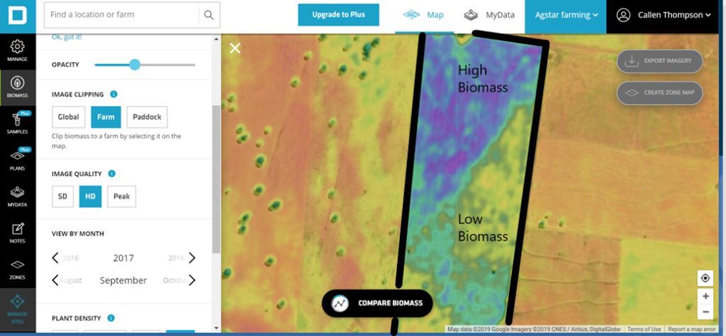
Being able to identify differences in biomass within a paddock can be very useful when making decisions. The difference in biomass in this paddock is due to a change in soil type.
You could also use this technology prior to doing routine paddock inspections to identify priority areas to check, for instance in the image below, the low herbage area may have been caused by disease or pest activity. Knowing the problem areas before you step foot in the paddock could save you a lot of time.
I have used Decipher and Data Farming in the past and found them both very user friendly. They currently provide free NDVI data with limited tools and you can subscribe to access additional tools and services. There are a number of other free and subscription based products available, have a look on-line and find one that fits your business.
So do you really need that drone, of course you do. As I said before, they are a lot of fun and who doesn’t like a tax deductable toy! Many producers I work with have them and use them on farm. From getting above a crop to look for pigs, checking stock and waters and taking photos for monitoring points, there is a lot of scope to integrate them into day to day activities. Also the image data you get from satellites is much courser than the data you can get from a drone so if you are doing on-farm trials where you want to see differences in greater detail, NDVI captured from a drone could be very useful.
If you would like more information on using NDVI data on your farm, contact your local Local Land Services Ag Advisory team member.